Heading through the Richardson Mountains.
This entry has a bit of information about the route that you might find useful.
Information
You can get the Dempster Highway Travelogue in Dawson or Inuvik. It's incredibly detailed and has a description of almost everything on the road, referenced by the kilometer. It even includes a detailed elevation chart of the route! The one we were given was a touch out of date and had a few mistakes. Be sure you get the errata which has all the corrections.
The NWT Tourist Information Centre in Dawson is very friendly to cyclists. They have lots of information, including past ride descriptions from other cyclists.
Road Conditions
The road from Dempster Junction (40km from Dawson) to 12km before Inuvik is all dirt. We found the dirt road to be in pretty great shape, with no washboard. Much of the time it's like riding on pavement.
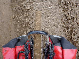
The exception is the infamous Dempster mud. When it rains hard the road gets a special kind of muddy. Think progress-halting, chain-eating, sticky mud. It's important to keep your drivetrain as clean as possible. A mudflap on your front fender to stop the front wheel from spraying the chain is a really good idea. However, even with this, our chains still took quite a beating. An internal drive hub would be really nice for this ride!
Another important consideration is construction. There are crews constantly working on the road in 5 - 20km sections. These can be very difficult to ride through, especially when combined with rain, and we've heard of cyclists having to hitch before. If the road is torn up the surface can be quite soft. In other sections they spread fresh loose gravel on the surface ... ugh.
On our trip it was raining on the horizon every day. Also, it rained hard almost every night. Be sure to be prepared for some wet weather and allow some time for weather related delays.
There's a wheel in there somewhere!
Supplies
Between Dawson and Inuvik, the only grocery store is in Fort McPherson (about 600km from Dawson). The Eagle Plains Lodge serves good breakfast, lunch, and dinner.
The NWT Tourist Information Centre will take a box of your food and find someone to drop it off in Eagle Plains for you. This is incredibly nice of them and saves carrying an extra 2-3 days of food on the bike.
Water
Water is plentiful for most of the route. However, the campgrounds do not have potable water and you need a method to treat it. The one gap in water is 110km between the Ogilvie River and Eagle Plains Lodge. Be sure to fill your water before you leave the Ogilvie River to start the climb!
Filling up from the Ogilvie River.
I think our schedule was about normal for the ride. But keep in mind that weather and mud can really slow you down. We heard of some cyclists about a week before us who took 14 riding days due to the rain!
Day 1: Dawson to Tombstone Territorial Campground (114.1 km / 6:54, heavy rain and tailwind)
Rained all day. Trending uphill all day, but the grade was so gradual that we didn't even notice.
Day 2: Tombstone Territorial Campground to Engineer Creek (125.2 km / 5:54, tailwind)
Short climb from the campground to the pass. Then two long and wonderful downhills to Engineer Creek. Beautiful scenery through the park!
Day 3: Engineer Creek to KM 286 (95.8 km / 5:59, showers, tailwind / sidewind)
Pretty riding along the Ogilvie River. Swam, washed clothes, and stocked up water before 7 mile hill. The hill wasn't too bad and had incredible views from the summit. Nice campsite with a bear barrel!
Day 4: KM 286 to Eagle Plains (85.2 km / 5:39, tailwind / sidewind)
Difficult riding with construction and mud. Good views.
Day 5: Rest day at Eagle Plains
Day 6: Eagle Plains to Rock River Campground (78.7 km / 4:51, tailwind / sidewind)
Easy and pretty riding. Good grades on the climb up from Eagle River. Lunch at the Arctic Circle.
Day 7: Rock River to Natainlaii Territorial Park (98.0 km / 6:16, tailwind)
Difficult climb up the last few km to the border through construction. Loose gravel on the descent from the border. Gorgeous riding through the Richardsons. Tough riding through gravel from Wright Pass to the Peel River.
Day 8: Natainlaii Territorial Park to Rengleng River (105.1 km / 6:14, rain and sidewind / headwind)
Stop in Fort McPherson for a few groceries. Boring riding through the delta. Stiff headwind from the river crossing to the Rengleng River. Good campsite at the Rengleng River.
Day 9: Rengleng River to Inuvik (94.4 km / 5:48, rain and headwind)
More boring riding through the delta towards Inuvik with a few great views. We had a tough headwind, rain and construction, which made this a difficult day.


No comments:
Post a Comment